
Climate in Gallatin County
The climate of Gallatin County varies greatly. Table 2.2 shows the variations between four stations in the county. Figure 2.3 shows when the precipitation typically falls during the year.
Gallatin County covers over 2,500 square miles of mountain lands varying in topography and climate from temperate river valleys to snow-capped peaks and open ranch lands. Nearly half of all the land in Gallatin County is under public ownership by the Gallatin National Forest, State of Montana, Bureau of Land Management or the National Park Service.
Gallatin County is large and diverse, featuring everything from the spectacular scenery of Yellowstone National Park (our first National Park) to lush farmland, and a growing economy of high-tech industries. Skiers, outdoor enthusiasts, wildlife watchers, mothers and fathers, business owners, vacationers, ranchers, retirees, students and many others have grown to love Gallatin County’s boundless opportunities.
The mountainous terrain of Gallatin County, ranging in elevation from approximately 4,000 feet to 10,700 feet (Wilson Peak), and its proximity to an active volcanic caldera, also presents geologic and terrain related hazards. The mountainous forests can spark large wildfires, and occasionally avalanches and landslides, while the active seismic area to the south makes Gallatin County prone to earthquakes and volcanic eruptions. These hazards are all formidable problems in Gallatin County.
Despite its natural beauty, man made hazards also exist in Gallatin County. The major US interstate, active railways, airports, and fixed facilities put Gallatin County at risk for transportation accidents and hazardous material releases. Dam failure, utility outages, terrorism, civil unrest, violence, communicable disease, bio-terrorism, and urban fire all have the potential to affect Gallatin County.
Gallatin County Statistics
| Fact | Gallatin County, Montana |
|---|---|
| Population estimates, July 1, 2025, (V2025) | 128740 |
| Population estimates base, April 1, 2020, (V2025) | 118957 |
| Population, percent change – April 1, 2020 (estimates base) to July 1, 2025, (V2025) | 8.2% |
| Population, Census, April 1, 2020 | 118960 |
| Population, Census, April 1, 2010 | 89513 |
| Persons under 5 years, percent | 4.5% |
| Persons under 18 years, percent | 17.7% |
| Persons 65 years and over, percent | 14.9% |
| Female persons, percent | 48.1% |
| White alone, percent | 92.5% |
| Black alone, percent | 0.7% |
| American Indian and Alaska Native alone, percent | 1.3% |
| Asian alone, percent | 1.7% |
| Native Hawaiian and Other Pacific Islander alone, percent | 0.1% |
| Two or More Races, percent | 3.7% |
| Hispanic or Latino, percent | 6.4% |
| White alone, not Hispanic or Latino, percent | 87.3% |
| Veterans, 2020-2024 | 5109 |
| Foreign-born persons, percent, 2020-2024 | 4.1% |
| Housing Units, July 1, 2025, (V2025) | 63368 |
| Owner-occupied housing unit rate, 2020-2024 | 61.1% |
| Median value of owner-occupied housing units, 2020-2024 | $667,600 |
| Median selected monthly owner costs – with a mortgage, 2020-2024 | $2,299 |
| Median selected monthly owner costs – without a mortgage, 2020-2024 | $750 |
| Median gross rent, 2020-2024 | $1,694 |
| Building Permits, 2025 | 1544 |
| Households, 2020-2024 | 51215 |
| Persons per household, 2020-2024 | 2.33 |
| Living in the same house 1 year ago, percent of persons age 1 year+, 2020-2024 | 82.2% |
| Language other than English spoken at home, percent of persons age 5 years+, 2020-2024 | 5.2% |
| Households with a computer, percent, 2020-2024 | 98.0% |
| Households with a broadband Internet subscription, percent, 2020-2024 | 93.3% |
| High school graduate or higher, percent of persons age 25 years+, 2020-2024 | 97.2% |
| Bachelor’s degree or higher, percent of persons age 25 years+, 2020-2024 | 54.3% |
| With a disability, under age 65 years, percent, 2020-2024 | 5.8% |
| Persons without health insurance, under age 65 years, percent | 8.9% |
https://www.census.gov/quickfacts/fact/table/gallatincountymontana/PST045225
History of Gallatin County
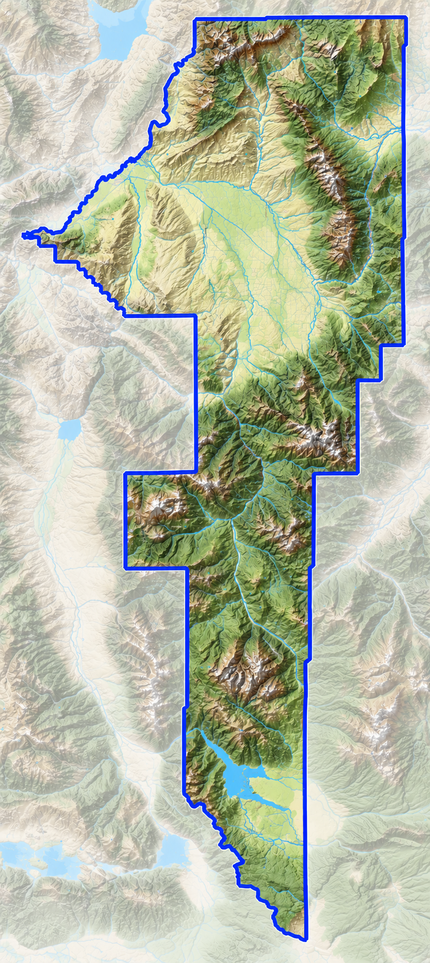
Gallatin County is located in south central Montana as shown in Map 2.1. According to the US Census data, Gallatin County has a 2021 estimated population of 122,713 and an area of 2,631 square miles. Within Gallatin County, 53,293 of the residents live within the city limits of Bozeman covering approximately 19 square miles. The City of Belgrade has a population of 10,460, The Town of West Yellowstone is around 1353, the Town Of Manhattan, 1691, and the City of Three Forks at 1944. Two other significant areas of population density exist in unincorporated areas, Big Sky with a resident population of 2767 and Four Corners coming in around 3406.
Gallatin County offers a wide variety of sights and outdoor activities including hunting, fishing, cross country skiing, swimming in hot springs, horse back riding, and camping trips. Wildlife abounds throughout the county. Bozeman, the county seat, is also known as one of the gateway communities to Yellowstone National Park. Major scenic roadways include U.S. Highway 191 from Belgrade south to West Yellowstone. Interstate 90 runs through Gallatin County from 10 miles west of Bozeman to Three Forks and runs parallel to the tracks that once carried hundreds of passengers on the Northern Pacific Railroad. Of course, the scenic and well traveled roadways also include access to many other less traveled portions of the county.
The Gallatin River flows through Gallatin County from the top of the Gallatin Canyon through Belgrade and on to Manhattan and Three Forks where it flows into the headwaters of the Missouri River. Gallatin County is bordered by Meagher County to the north, Park County to the east, Jefferson and Broadwater Counties to the west and Yellowstone Park to the south. The elevation ranges from approximately 4,000 to 10,700 feet.
Much of the Yellowstone River basin was inhabited by the Crow Indians until the expedition of Lewis and Clark traveled through in the early 1800’s. In the decades that followed, the region was explored by trappers, gold diggers, and early settlers. Yellowstone National Park became the nation’s first national park in 1872. The Northern Pacific Railroad, completed in the 1880’s, increased the population in Gallatin County from 1880 to 1890. Steady growth has brought the population to what it is today.
Emergency Management Service Area